The main goal of the Digital Information System for Polish Maritime Areas (CSI-POM www.csipom.pl/en/) is to identify the dynamics, structures and spatial-temporal variability of physical processes occurring in the marine environment of the southern Baltic Sea, using modules/applications developed under the CSI-POM project based on numerical modeling.
The innovation of this project lies in the development of new tools to understand physical processes in the southern Baltic Sea:
i) determination of the thermocline, halocline, and pycnocline for the entire model domain,
ii) spatial-temporal analysis of water column structures for examined parameters such as temperature, salinity, and currents;
iii) automatic detection of marine eddies;
iv) investigation of water mass inertia in response to forecasted wind forcing,
v) automatic detection of coastal upwelling.
The CSI-POM service addresses issues in the maritime economy and fisheries, associated with the need for a reliable and accurate tool to observe changes in the marine environment.
These include:
planning and evaluating optimal hydrodynamic conditions for undertaken ventures,
making optimal decisions during the planning of activities in various sectors of the maritime economy,
improving the safety and efficiency of operations.
Informed management of investments will help avoid unnecessary losses and schedule changes.
The visualization of model results and their presentation in the form of real-time maps with a 48+ hour forecast is available to a wide audience via the CSI-POM online portal/service (www.csipom.pl/en/).
CEMBS-PolSea Model
The main objective of the "Digital Information System for Polish Maritime Areas (CSI-POM)" project is to develop an advanced numerical tool that allows for effective monitoring and forecasting of hydrodynamic (CSI-POM Stage 1) and biochemical conditions (CSI-POM Stage 2) in the southern Baltic Sea. CSI-POM Stage 1 (Figure 1) aims to provide a comprehensive solution integrating numerical modeling with modern tools for analyzing physical processes, offering more complete information about the state of the marine environment.
The 3D CEMBS-PolSea model developed as part of the CSI-POM project is derived from the Community Earth System Model (CESM), with a G-type configuration, which is a coupled global climate model developed by NCAR. For the purposes of the CSI-POM project, the CESM model was scaled down and adapted to the region of the Polish Maritime Areas and further developed at the Institute of Oceanology of the Polish Academy of Sciences. The horizontal resolution of the 3D CEMBS-PolSea model is 575 m (1/192°), with 66 vertical layers ranging in thickness from 5 to 83 meters.
The model's domain to the west and north borders the open Baltic Sea, necessitating the provision of boundary conditions to the model. Data for the boundary conditions are supplied by the 3D CEMBS model for the Baltic Sea with a horizontal resolution of 2 km. The 3D CEMBS-PolSea model is driven by meteorological forcing from the UM (Unified Model) developed at the Interdisciplinary Centre for Mathematical and Computational Modeling of the University of Warsaw.
In the 3D CEMBS-PolSea model, river flow data come from three sources:
The SWAT hydrological model, developed as part of the "Integrated Information and Prediction Service WaterPUCK" project (Dybowski et al. 2020-2022, Dzierzbicka-Głowacka et al. 2022).
The HYPE hydrological model, which provides publicly available historical data on river flow.
Operational river flow data from the Institute of Meteorology and Water Management (IMGW) database, purchased with CSI-POM project funds.
The 3D CEMBS-PolSea model includes 21 rivers flowing into the Baltic Sea from Polish territory and also has a satellite data assimilation module for sea surface temperature. A detailed description of the model and its validation is presented in the article by Dybowski et al. (2024, Oceanologia).
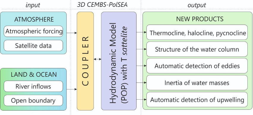
Figure 1. The structure of the Digital Information System for Polish Maritime Areas (CSI-POM)
As part of the project, new numerical tools/modules were developed to determine the structures, dynamics, and variability of physical processes in the southern Baltic Sea.
An inseparable part of the "Digital Information System for Polish Maritime Areas" is the visualization of results and their dissemination to the public. The developed CSI-POM system allows the creation of spatial, temporal, and point-based maps and characteristics for the studied parameters and physical processes. These results are presented on a web portal in real time and as forecasts for the next two days. They provide information about the current environmental conditions and potential hazards in the open sea and coastal zones of Poland.
CSI-POM System
Access to all services is provided through the website www.csipom.pl website under the "PRODUCTS" tab (Figure 2):
HYDRODYNAMIC PARAMETERS
TEMPORAL VARIABILITY
VERTICAL SECTIONS
SPECIFIC LAYERS
VORTEX DETECTION
INERTIA OF WATER MASSES
UPWELLING DETECTION
A detailed description of the CSI-POM portal/system is presented in the article by Dzierzbicka-Głowacka et al. (2024) in the “Oceanologia” journal.
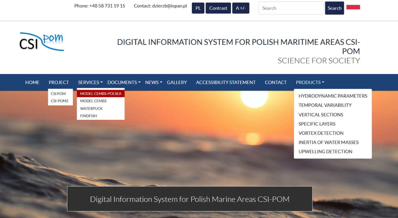
Figure 2. Screenshot of the CSI-POM webpage window.
Below are sample parameters for each PRODUCT of the CSI-POM portal/service.
Product: HYDRODYNAMIC PARAMETERS – parameters:
Temperature
Salinity
Currents
Sea level
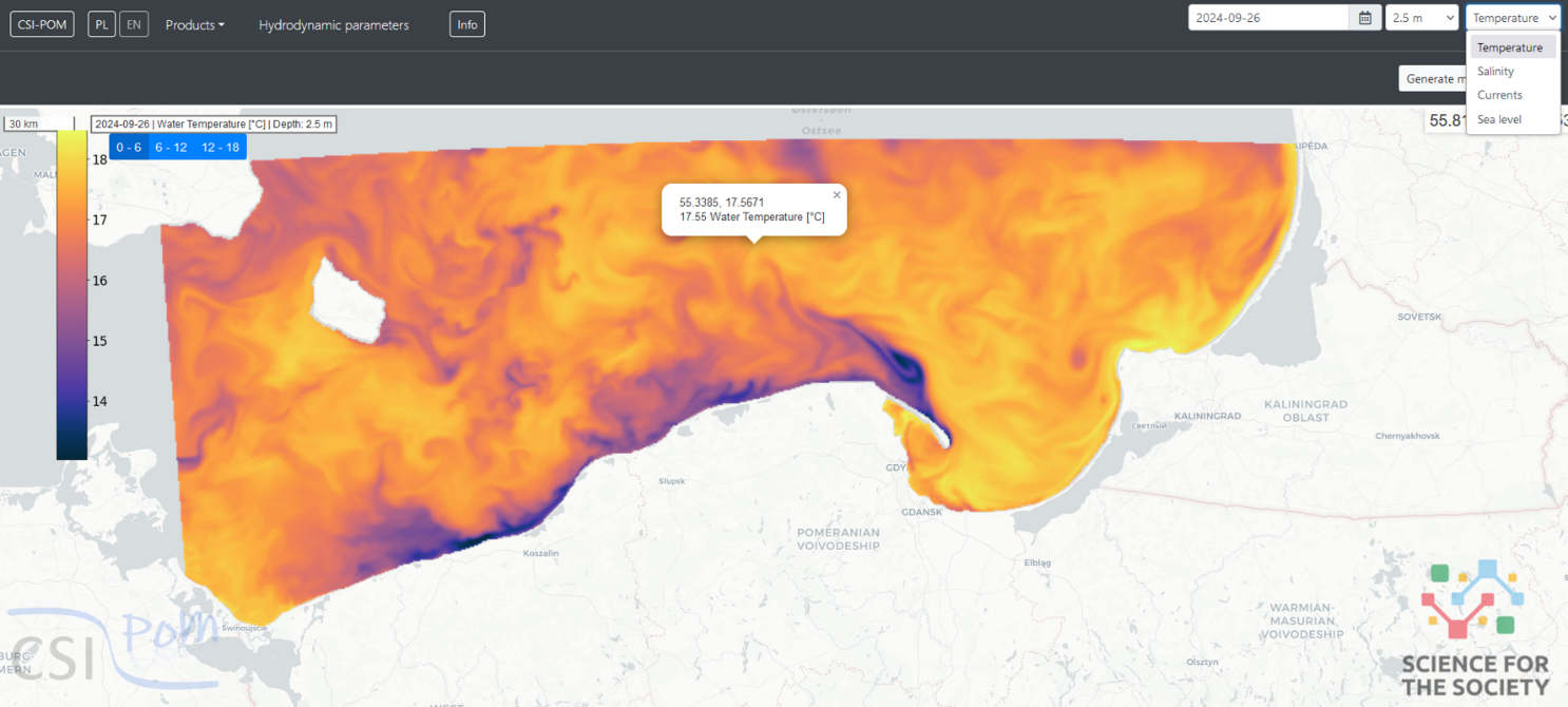
Figure 3. Screenshot of the CSI-POM webpage window after selecting the product "Hydrodynamic Parameters," the parameter "Temperature," as well as the date and depth.
Product: TEMPORAL VARIABILITY – parameters:
Temperature
Salinity
Currents
Sea level
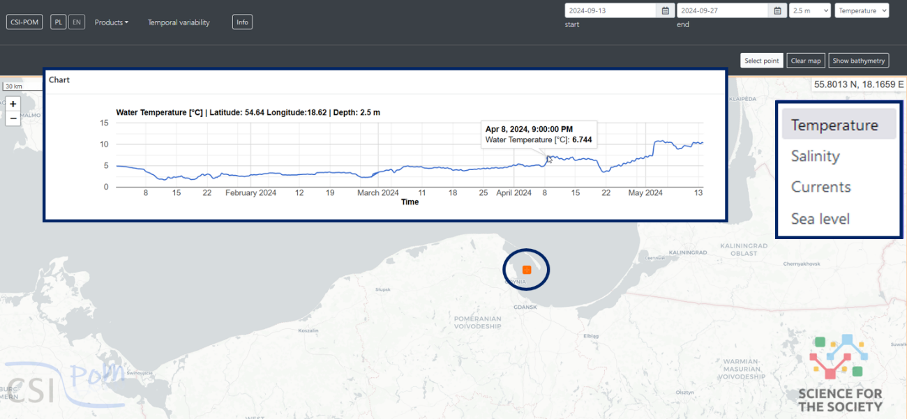
Figure 4. Screenshot of the CSI-POM webpage window after selecting the product "Temporal Variability," the parameter (e.g., "Temperature"), the time period, and marking a point on the map for which a temporal variability chart has been generated.
Product: VERTICAL SECTIONS – parameters:
Temperature
Salinity
Currents
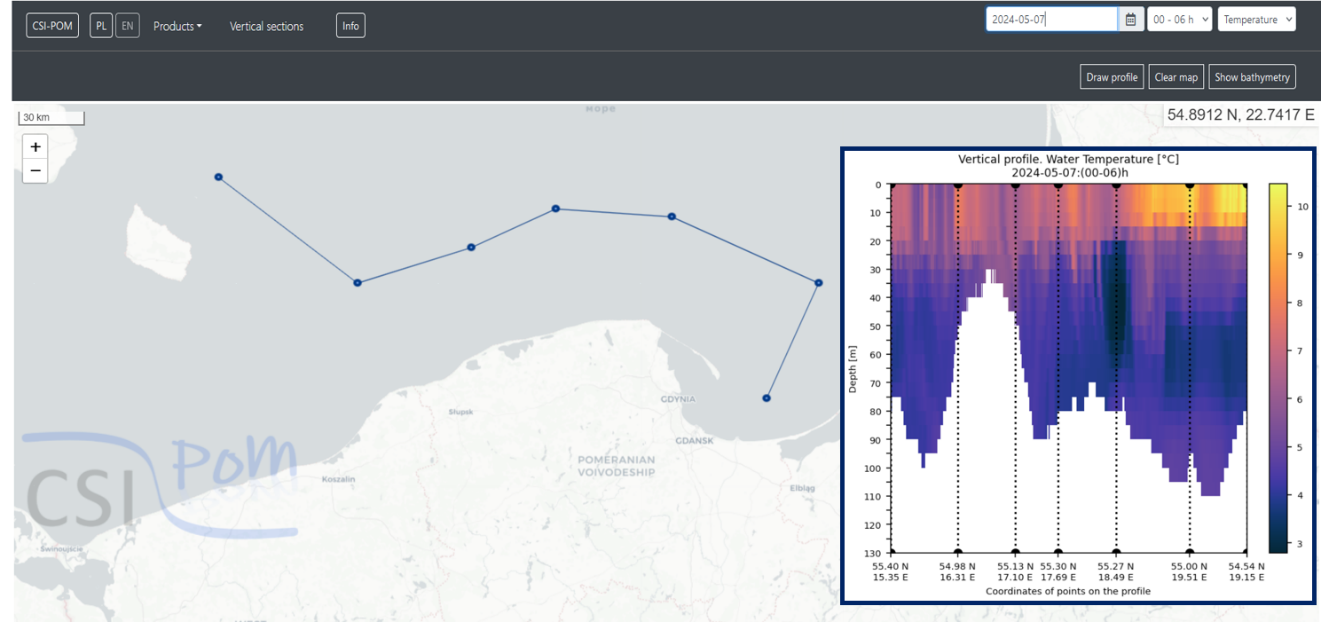
Figure 5. Screenshot of the CSI-POM webpage window after selecting the product "Vertical Sections" the parameter (e.g., "Temperature"), the date, and drawing a profile along which the vertical cross-section was generated.
Product: SPECIFIC LAYERS – parameters:
Thermocline Top
Halocline Top
Pycnocline Top
Thermocline Bottom
Halocline Bottom
Pycnocline Bottom
Thermocline Thickness
Halocline Thickness
Pycnocline Thickness
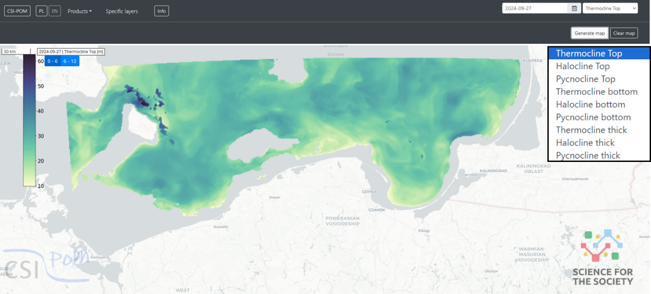
Figure 6. Screenshot of the CSI-POM webpage window after selecting the product “Specific layers”, the parameter (e.g., "Thermocline Top"), and the date.
Product: VORTEX DETECTION – parameters:
Current
Sea level
Gamma 1
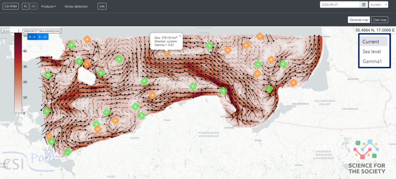
Figure 7. Screenshot of the CSI-POM webpage window after selecting the product “Vortex Detection”, the parameter (e.g., "Current"), and the date.
Product: INERTIA OF WATER MASSES – parameters:
Trend
Response time
High water level
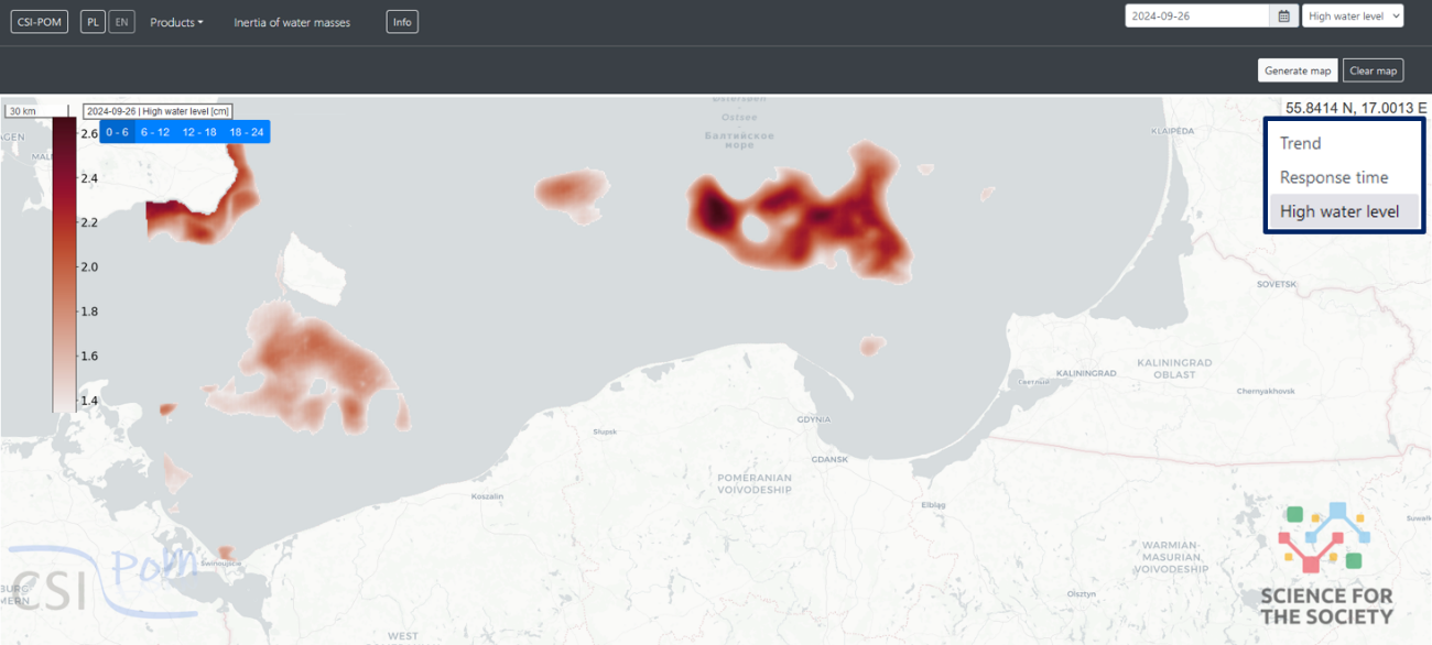
Figure 8. Screenshot of the CSI-POM webpage window after selecting the product “Inertia of water masses”, the parameter (e.g., "High water level"), and the date.
Product: UPWELLING DETECTION
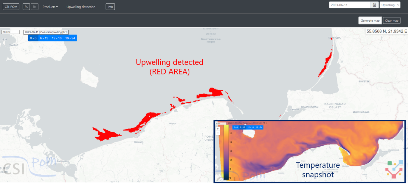
Figure 9. Screenshot of the CSI-POM webpage window after selecting the product “Upwelling detection”, and the date.
Each PRODUCT is accompanied by an "Info" icon on the top bar. Clicking it displays information about the product and its parameters (Figure 10).
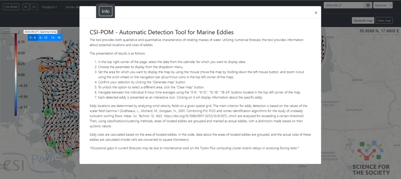
Figure 10. Screenshot of the CSI-POM webpage window after selecting the "Info" icon for the product „Vortex detection".
Summary
In oceanographic research of the World Ocean, the systems of inland seas hold an important place. The functioning of such systems is a complex process, which highlights the need to study the environment of the Baltic Sea, both for scientific understanding and due to its economic and political significance for our country.
Baltic Sea is one of the largest brackish water bodies in the world. The inflow of dense, salty waters from the North Sea is uneven, and these waters spread in the bottom layers of the Baltic. This leads to both a strong halocline and the formation of significant salinity gradients within the water column. Salinity decreases with distance from the Danish Straits along the transit zone, which is the axis of the deep basins of the Baltic, where inflow waters propagate. Due to river runoff, surface waters are characterized by reduced salinity, while bottom waters, due to the influence of inflows from the North Sea, exhibit increased salinity. Additionally, mixing processes between the upper and lower layers reduce the vertical salinity gradient, which is why many researchers consider the Baltic Sea to be an estuary, where this process is common (Marmefelt, 1993; Stigebrandt, 1983).
The average salinity of surface waters in the Baltic is five times lower than that of the ocean, at approximately 7.5 PSU (Leppäranta, 2009).
Due to its geographical location, the Baltic is a relatively cold sea. It is located in the northern temperate climate zone and is subject to the influence of eastern, continental air masses. Its specific bathymetry, which isolates it from the influence of warm water from the Gulf Stream, along with the aforementioned factors, causes the surface water temperature in winter to be lower than that in the North Sea. The temperature in the surface layer varies between 0 and 18°C.
Specific environmental conditions of the Baltic Sea affect its ecosystem. It is characteristic of the Baltic to host fauna typical of low-salinity environments. Additionally, a distinctive feature of this sea is the regular spring-summer algal blooms, which have become a significant environmental and economic problem. Over thirty species of phytoplankton in the Baltic are classified as harmful to human health (Öberg, 2016).
Studying the ever-changing environment presents a tremendous challenge for researchers from various scientific disciplines. Emerging new technical solutions, on one hand, facilitate the work of scientists, but on the other hand, they do not offer a perfect solution.
The efficiency of numerical research is incomparably greater than the efficiency of field studies using buoys, ships, or satellite measurements. This explains the widespread use of mathematical models and computer simulations in the digital age as new methods of understanding the laws governing the natural world. This is especially true for issues at the intersection of multiple disciplines, which is often the case in oceanographic research.
Numerical modeling of hydrodynamic and biochemical phenomena in the studied water body is a complex task. It is necessary to consider the inflows of fresh water (rich in nutrients) from rivers and the inflows of salty water from the North Sea reaching the area near the bottom. The input data for the model, such as information on river inflows, atmospheric data, and boundary conditions, must be of high quality. These are the main forcing factors for the model, and their quality has a significant impact on the accuracy of the results and their alignment with reality. Due to the fact that very dynamic changes occur in the environment, only simultaneous environmental/measurement and modeling studies can provide the most reliable picture of the actual state of the examined water body. High-resolution time-space results can provide local-scale information about vortex formation, mixing of waters with different densities, or the formation of intrusions. Additionally, studying the basic parameters of the aquatic environment and the processes occurring within it forms the basis for the development of new research hypotheses and the dissemination of knowledge to foster cooperation between entities operating in the scientific field and those in the socio-economic sphere.
At the Marine Ecohydrodynamics Laboratory at the Institute of Oceanology of the Polish Academy of Sciences in Sopot, a 3D ecosystem model called CEMBS has been developed to determine the basic hydrodynamic and biochemical parameters of the Baltic Sea environment.
The quality of the presented results varies depending on the type of parameter, geographic region, or depth, reflecting the current state of knowledge about the functioning of the marine ecosystem. The model requires further improvements and refinements to specific areas to become a reliable tool for assessing the condition of the Baltic Sea environment and forecasting its changes. Further enhancement and expansion of the 3D CEMBS model, from a resolution of 2 km to a much higher resolution (0.5 km), along with the development of new innovative tools describing marine environmental processes, will extend its range of applications.
Currently, several scientific institutions in Europe - located in Sweden, Denmark, Finland, and Poland - are working on modeling the hydrodynamic parameters of the Baltic Sea (with existing models such as HIROMB, RCO, NEMO, SCOBI, DMI/ERGOM, HIRLAM, BALTSEM, CEMBS, M3D, and others). All of these models only determine basic hydrodynamic parameters of the marine environment. However, none of them comprehensively, in an operational mode, simultaneously forecast both basic hydrodynamic parameters and the tools proposed in the CSI-POM project (Digital Information System for Polish Maritime Areas), which define the spatio-temporal, strongly layered structure of the studied area. The article by Dzierzbicka-Głowacka et al. (2024) presents in detail the functioning of the CSI-POM Digital Information System on the environment of Polish maritime areas – Stage 1, which enables monitoring hydrodynamic conditions. This greatly facilitates the forecasting of threats (such as the detection of marine eddies, upwelling detection) and economic activities (such as offshore renewable energy, transport, and logistics activities) in Polish maritime areas.
Environmental protection policy must be integrated with economic policy. For this purpose, appropriate management programs based on the concept of sustainable development must be created, aiming at economic development in the sector while maintaining environmental conditions. It is also important to promote knowledge about the functioning of water systems and the impact of economic activities on the natural environment to minimize future economic impact on the environment.
There are many social groups targeted by the proposed project. The main and direct goal is for the proposed actions to serve as a means to convince decision-makers in maritime industries to collaborate and benefit from the skills and knowledge of scientists.
The developed CSI-POM system is available free of charge (via the website www.csipom.pl) to everyone and will allow interested users to obtain information about the state of the marine environment. It will be a valuable source of information for scientists, students, tourists, and also decision-makers, maritime services, and local communities. Moreover, the system will contribute to increasing public ecological awareness and a sense of responsibility for the environment.
Planned Effects of the CSI-POM Project Implementation:
Increase in business efficiency;
Improvement of work safety at sea;
Strengthening self-control of work at sea;
Sustainable development of the maritime economy;
Increase in knowledge about the southern Baltic environment;
Protection of protected areas and Natura 2000 through public education;
Reduction of water pollution;
Establishment of a cooperation network between scientists and SMEs (Small and Medium Enterprises).
Scientists, society, and the state are obliged to protect the natural environment of the Baltic Sea and to comply with relevant international conventions and legal regulations, such as the Water Framework Directive, the EU Marine Strategy Framework Directive, the European Earth monitoring program GMES (Global Monitoring for Environment and Security), and others.
Prof. dr hab. Lidia Dzierzbicka-Głowacka
Institute of Oceanology of the Polish Academy of Sciences
Publication financed from the state budget under the programme of the Minister of Education and Science (Poland) entitled "Science for Society" No. NdS/546027/2022/2022, amount of funding PLN 1 702 130.65, total value of the project PLN 1 702 130.65